We left the spectacular Grand Coulee Dam and headed for Moses Lake, WA for the night. The drive takes you down the Grand Coulee on WA 155. The floods from ice-age Lake Missoula scoured a huge trench through the lava-encrusted landscape. Twenty-seven miles of the road runs along Banks Lake, seen below. It's named for the construction engineer who supervised the building of Grand Coulee Dam. "Coulee" is French for canyon; French fur trappers brought the word from Canada. The basalt columns of the Columbia Plateau were easy prey for the huge glacial floods the roared down from Idaho and Montana during the last ice age.
As you drive along the shores of Banks Lake, you'll see a sign for Northrup Canyon State Park. It's a spectacular side canyon that used to be a dumping ground for all the tin cans from the building of Grand Coulee dam. "Canning Parties" in the canyon used to be people rooting around in the old cans for treasures, although we think you are supposed to leave them as artifacts. We didn't do any "canning" -- we were too taken with the scenery.
In flat light, the canyon would have been primarily shades of gray and green. The spring sun hit it at an angle revealing an amazing array of colors.
As witnessed after the Mt. St. Helens eruption, life comes back fairly quickly. Of course, it's been eons since the lava actively flowed through here, but it's still some tough country to get your feet down in if you are a plant. But the canyon was fairly lush, considering the low annual rainfall and brutal summer temperatures.
There were plants growing right out of the sides of boulders in the canyon.
As we exited Northrup Canyon, we looked back north for another view of the Grand Coulee.
Not far from Northrup Canyon is Steamboat Rock State Park, named after a rock that looks like a steamboat -- sort of, I guess, if you are a pioneer. They could have just as easily called it " Big Honkin' Stand-Alone, Irrepressibly Photogenic Mesa."
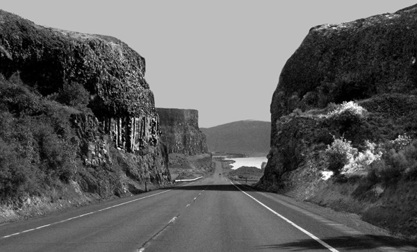
As you continue down The Grand Coulee, you flit in and out of huge basalt formations. You could go into this part of Grand Coulee on a cloudy day or two or three and do entire portfolios of black and white shots of the intersecting shapes you encounter.
In relative low sunlight, like in spring and fall, the colors on the canyon walls start to be well worthy of note. I'm sure most people blast through what could be considered a somewhat "barren" landscape, but in low light at slow speeds, it really reveals another picture of itself entirely.
There's evidence of a violent and highly dynamic geologic past all around you.
Further down the road toward Moses Lake is one of the most dramatic geologic features in Washington -- Dry Falls. Dry Falls is the remnant of a falls that dwarfed Niagra Falls when Ice Age Lake Missoula let loose as the ice dam holding it back gave way, releasing a torrent of Biblical proportions. Today's town of Missoula, MT would have been under nearly 1000 feet of water before the ice dam breached.
The map above is from Montana Natural History Center's Glacial Lake Missoula website and shows the flooded area after the release of Lake Missoula. In actuality, this flooding wasn't a singular event but a series of massive floods over a long period as the ice dam reformed and then breached over and over again. Not a good flood plain to set up camp. Dry Falls is located at the number 5 on the map.
The ice dam holding back the water was estimated at 2,000 feet high holding back water equivalent to Lake Eire and Lake Ontario combined. When it gave way, the water surged out in a wall the size of a 20 story building and 10 miles wide, and carried with it boulders the size of cars. The scouring power of that water was nearly beyond imagining. The drawing below is from the Visitor's Center at Dry Falls Park.
Today you can stand on what was the brink of the falls and look down into the basin created when that mass of water dropped hundreds of feet over an embankment, eating out what are known as plunge pools at the base of the falls.
When you stand at the observation point you look down into these plunge pools, now ponds full of fish and the occasional angler in a small boat. The area is also a haven for waterfowl and wetland creatures of all sorts.
The photo above was taken from the observation point near the Visitor's Center. If you had been unfortunate enough (as some Paleo-Indians might well have been) to be at this spot when the water reached it, the scene above would have looked like the artists's drawing below from the Visitor's Center.
The entire rim of the panorama shot below would have been the brink of a falls hundreds of feet deep and miles wide around the rim. You probably would have been able to hear it for 50 miles in those days.
After Dry Falls, we drove straight to Moses Lake to get to our motel as the light was fading. We didn't realize it at the time, although I'd lived in Washington for over a decade at one point, that Moses Lake was the Carp Capital of the west at one point. You can still see the canals and ponds where they were raised by the metric ton.
Text by Brian and Louise, Photos by Brian. Text and Photos copyright 2008 Goin Mobyle, LLC. 


 Road Down the Coulee


